Avenza Maps is a powerful offline mapping platform designed to help users explore, navigate, and track outdoor adventures with precision and confidence. Whether you're hiking remote trails, biking through national parks, or creating your own custom maps, Avenza Maps offers a robust suite of tools and access to a vast library of professional maps to support every journey.
Offline GPS Navigation and Real-Time Tracking
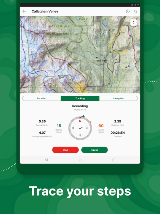
- Locate your position using your device’s GPS, even without internet or cellular service.
- Record GPS tracks to monitor your route, distance, elevation, and duration.
- Use compass tools to navigate toward specific features or waypoints.
Custom Map Import and Personalization
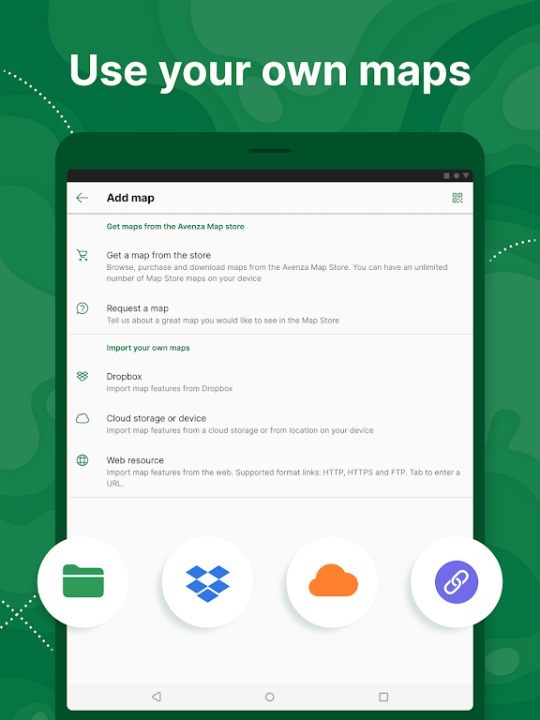
- Import unlimited geospatial PDF, GeoPDF®, and GeoTIFF maps with Plus or Pro subscriptions.
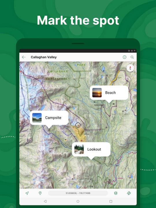
- Add placemarks, notes, and geotagged photos to any location on your map.
- Style placemarks with recreational symbols and organize them for easy reference.
Advanced Mapping Tools and Measurement
- Measure distances between points and estimate travel times.
- Convert recorded tracks into area measurements for land management or planning.
- Lock map orientation and use GPS averaging for improved accuracy (Pro feature).
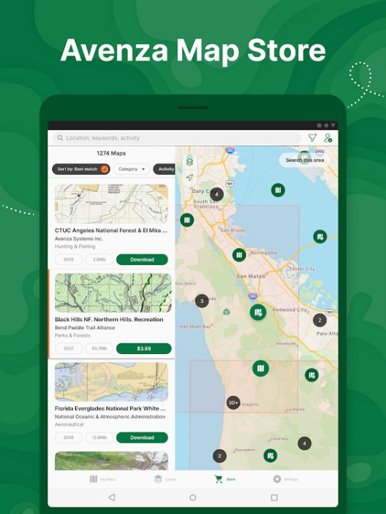
Extensive Map Store Access
- Browse and download maps by activity, region, or publisher from the in-app Map Store.
- Access premium maps from trusted sources like National Geographic, USGS, NOAA, and the National Park Service.
- Choose from topographic, nautical, city, trail, and travel maps for any terrain or purpose.
Geofencing and Professional Integration
- Create up to 50 geofences with Plus or unlimited geofences with Pro.
- Receive geofence notifications when entering or exiting defined zones.
- Connect to high-accuracy GPS devices via Bluetooth for professional-grade tracking.
Data Compatibility and Export Options
- Supports KML, GPX, and CSV formats for importing and exporting data.
- Pro users can import and export Esri® Shapefiles and manage custom symbology sets.
- Share your maps and data with teams or collaborators for coordinated fieldwork.
Subscription Tiers for Every User
- Free: Access to the Map Store, GPS location, and limited custom map imports.
- Plus: Unlimited custom map imports and geofencing for recreational users.
- Pro: Full access to advanced tools, professional integrations, and priority support for commercial, academic, and government use.
Frequently Asked Questions
Q: Can I use Avenza Maps without an internet connection?
A: Yes, all maps and GPS features work offline once maps are downloaded to your device.
Q: What types of maps are available in the Map Store?
A: The store includes hiking, topographic, nautical, city, and travel maps from thousands of publishers.
Q: Can I import my own custom maps?
A: Yes, users with Plus or Pro subscriptions can import unlimited geospatial PDF, GeoPDF®, and GeoTIFF maps.
Q: Does Avenza Maps support external GPS devices?
A: Yes, Pro users can connect high-accuracy GPS devices like Trimble, Bad Elf, and Dual via Bluetooth.
Q: What file formats does Avenza Maps support?
A: The app supports KML, GPX, CSV, and Esri® Shapefiles (Pro only) for data import and export.
Version History
v3.14 —— 6 Jun 2025
Navigation accuracy improved—arrival radius values tweaked for better precision.
Map store enhancements—preview individual bundle maps and view more map area while browsing.
GPX export optimized—smoother data handling.
Bug fixes & usability improvements—refined overall experience.
v3.13.1 —— 23 Dec 2020
GPX import unlocked—now available with the free subscription.
Map sorting added—organize maps by recently viewed.
Dynamic unit scaling improved—more accurate measurements.
Bug fixes & usability improvements—enhanced performance.
v3.12 —— 10 Nov 2020
Text scaling fixed (iOS)—improved readability.
UTM coordinate support—map datum now properly handled.
Magnetic north accuracy—better course and projection alignment.
Library updates—all third-party libraries refreshed.
Bug fixes & performance improvements—smoother operation.