Navigate smarter and explore confidently with a travel assistant designed for accuracy, privacy, and offline independence. MapXplorer: Navigation, Radar blends GPS precision with 3D mapping and radar functionality, ensuring users enjoy uninterrupted guidance even in remote areas. With offline access, vehicle route planning, and environmental awareness features, this app is built for drivers, motorcyclists, and outdoor explorers seeking reliable, real-time navigation without relying on internet coverage.
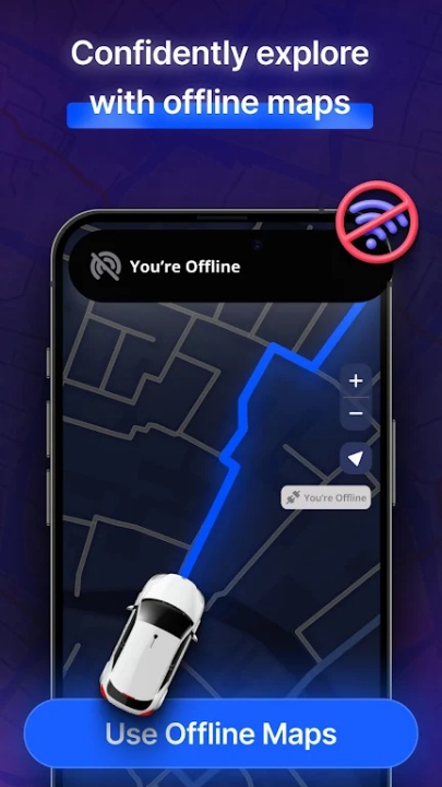
Comprehensive Offline Navigation System
Access full-scale mapping and route guidance without needing data or Wi-Fi:
- Download maps for your destination or region and use them entirely offline
- Search locations and plan trips without connectivity constraints
- Explore detailed grids and map overlays optimized for low-bandwidth environments
- Perfect for backcountry travel, rural driving, and international roaming scenarios
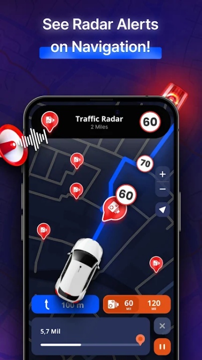
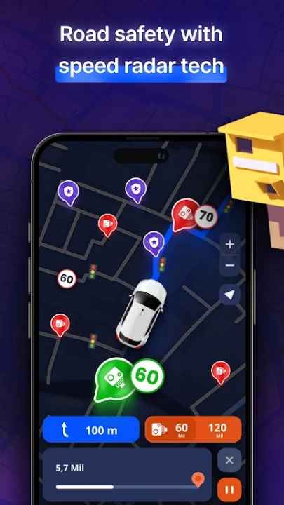
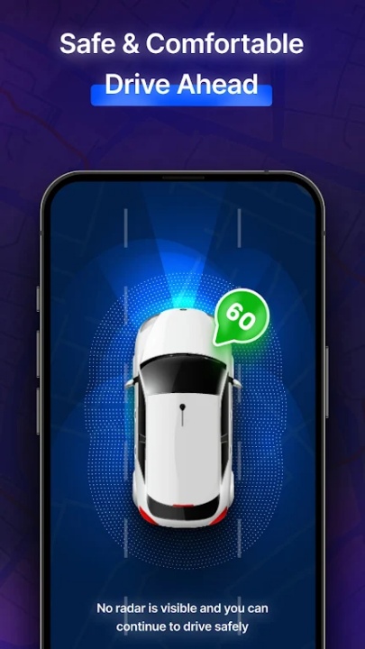
Advanced Radar Awareness Features
Stay protected and informed through radar-based alerts and monitoring:
- Receive warnings about fixed speed cameras and speed traps in real-time
- Identify nearby police patrols, mobile radars, drones, and surveillance devices
- Review traffic hazards, congestion zones, and high-incident intersections before approach
- Respond to alerts quickly with proactive route adjustments
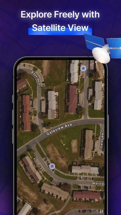
High-Fidelity Mapping and Exploration
Explore cities and roads with versatile map modes:
- View terrain in realistic 3D and toggle to satellite mode for overhead visibility
- Assess routes, landmarks, and road infrastructure with high detail
- Transition between viewing modes effortlessly to suit exploration needs
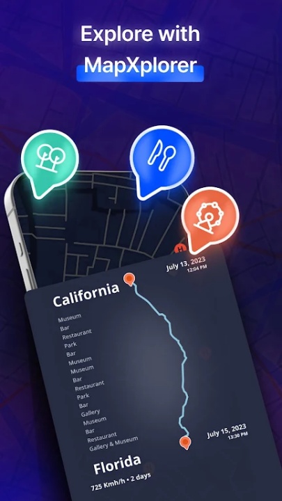
Points of Interest and Trip Enhancement
Boost your travel experience with contextual discovery tools:
- Locate rest stops, gas stations, restaurants, and tourist attractions near your position
- Identify key facilities before arrival, ensuring preparation and comfort
- Plan routes with convenience-based stop selection for optimized journeys
Multi-Vehicle Routing Options
Tailor navigation settings to match vehicle type:
- Set routing preferences for cars, trucks, or motorcycles
- Receive vehicle-specific alerts such as clearance warnings and route suitability
- Optimize paths for traffic flow, road conditions, and vehicle size
Real-Time Alerts and Situational Updates
React promptly to changing road conditions with live notifications:
- Get updates on accidents, weather disruptions, lane closures, and construction zones
- Avoid congestion and reroute based on current conditions without delay
- Maintain travel awareness even when transitioning between offline and online modes
Intuitive Design and Smart Controls
Enjoy clean, responsive UI controls that support stress-free navigation:
- Search, zoom, and pan through map interfaces with touch-friendly gestures
- Bookmark favorite destinations and frequently visited spots
- Interface supports quick-access tabs for alerts, history, and preferences
Data Privacy and Secure Operation
Maintain control over personal location and usage data:
- Location services are exclusively used for navigation purposes
- No data harvesting or background tracking beyond active app functionality
- Subscriptions and app settings are user-managed with full transparency
Subscription and Access Options
Engage with core features for free, or enhance functionality with premium upgrades:
- Core offline navigation and radar tools are available to all users
- Subscriptions unlock ad-free navigation, personalized insights, and premium map tools
- Subscription auto-renews unless canceled through account settings
Frequently Asked Questions
Q: Does MapXplorer work without an internet connection?
Yes, all maps and navigation features support offline use once downloaded.
Q: Can the app detect speed traps and traffic radars?
Yes, it provides real-time alerts for speed cameras, radars, and similar hazards.
Q: Are satellite and 3D views available?
Yes, users can toggle between detailed 3D and satellite modes.
Q: Does it support motorcycle and truck navigation?
Yes, routing preferences can be set based on vehicle type.
Q: Are real-time traffic alerts included?
Yes, alerts cover congestion, accidents, police activity, and more.
Q: Can I search for locations offline?
Yes, the app supports offline search and discovery after map download.
Q: Is personal data collected or shared?
No, location data is used strictly for navigation purposes.
Q: What does the subscription include?
Premium users get ad-free usage, advanced tools, and personalized enhancements.
Version History
v7.9 —— 7 Jun 2025
Improved radar alerts & speed camera detection—enhanced safety notifications for drivers
Expanded radar coverage & speed limit accuracy—powered by real-time GPS data
Radarbot integration—receive live traffic and speed trap alerts
Map visuals enhanced—refined graphics for smoother offline navigation
New HUD (Head-Up Display) mode—safer night-time driving with directional overlays
v7.5 —— 7 May 2025
Same updates as v7.9—continued improvements to radar detection, map quality, and HUD experience
v7.0 —— 6 Apr 2025
Same updates as above—full feature rollout begins for safer and more immersive offline travel