Fishing Points is the all-in-one fishing app trusted by over 10 million anglers worldwide. Designed for both saltwater and freshwater fishing, it provides comprehensive tools to plan and execute successful trips on open seas, lakes, and rivers. The app combines detailed fishing forecasts, advanced mapping features, and logging tools to help anglers discover the best fishing times, understand fish behavior, and maximize their catch.
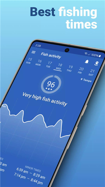
Feeding Times Forecast
Fishing Points provides hourly feeding time predictions with major and minor intervals, allowing anglers to know when fish are most active. Daily fish activity charts and a comprehensive best fishing times calendar, including species-specific insights for bass and other popular catches, help plan trips strategically.
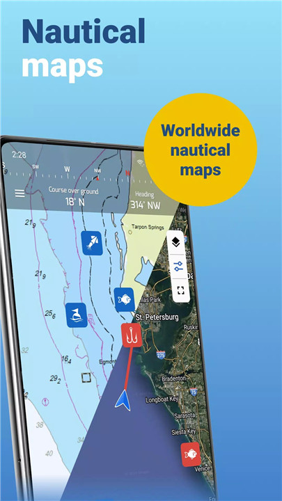
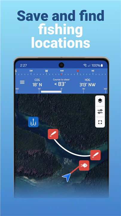
Location & Maps
The app offers advanced map tools for finding and saving fishing spots, hotspots, waypoints, trolling paths, and trotlines. Locations can be marked with over 40 icons and 10 colors for easy identification. Enhanced mapping includes detailed satellite views, worldwide nautical charts, and offline mode for NOAA marine maps. Unique to Fishing Points, users can visualize lake depths and underwater contours in select states (FL, MN, NE, NH, ND, WA) to locate hidden hotspots.
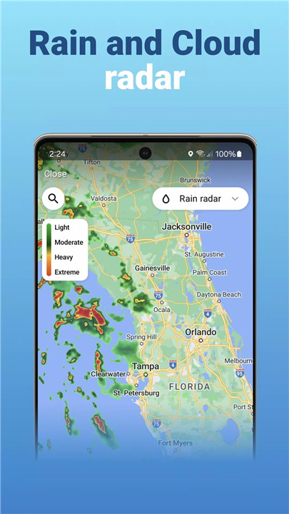
Fishing Weather & River Data
Stay informed with accurate, hourly weather forecasts tailored for fishing, including humidity, precipitation probability, UV index, wind speed, gusts, direction, and barometric pressure. Live severe weather alerts and rain radar ensure safety during trips. River anglers can access current water levels and flows from over 35,000 river stations, providing a complete view of freshwater conditions.
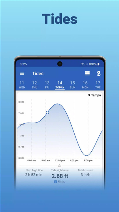
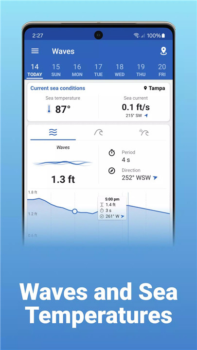
Tides, Solunar & Marine Forecast
The app covers detailed hourly tidal charts, high and low tide predictions, and tidal current information. Solunar data includes sunrise, sunset, moonrise, moonset, sun and moon positions, and moon phases. Marine anglers benefit from hourly wave forecasts, sea temperatures, and ocean current data, giving a full picture of conditions at sea.
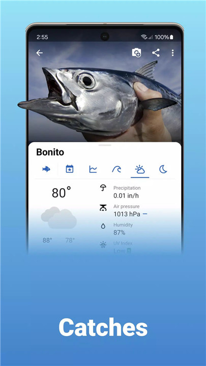
Catch Logging & Fish Species Information
Anglers can create detailed catch logs, including photos, weight, and length, with automatic integration of weather, solunar, and tide data. The app provides species-specific information, covering bass, trout, snapper, snook, drum, grouper, catfish, and more, along with fishing regulations, bag limits, and open seasons for selected U.S. states (FL, TX, GA, NC, LA).
Sharing & Integration
Fishing Points allows importing KMZ or GPX files from other GPS devices or apps. Locations, catches, and photos can be shared with friends, fostering a community of anglers.
FAQs
1. Which fishing locations are available in Fishing Points?
The app provides access to worldwide fishing spots, including lakes, rivers, and seas. Lake depth maps and contours are available for FL, MN, NE, NH, ND, and WA.
2. How does the feeding times forecast work?
Fishing Points offers hourly feeding predictions with major and minor intervals, daily fish activity, and a best fishing times calendar. Users can also set smart notifications for peak times.
3. Can I use the app offline?
Yes, Fishing Points includes offline mode with nautical charts from NOAA, allowing anglers to navigate and access key information even without an internet connection.
4. What weather and marine data does the app provide?
The app provides hourly forecasts for temperature, rain probability and intensity, wind speed and direction, UV index, barometric pressure, wave height, sea temperature, and ocean currents.
5. How does catch logging work in the app?
Users can log catches with photos, weight, and length. Weather, solunar, and tide data are automatically added, and logs can be synced across devices or shared with friends.
Version History
v4.5.6—22 Dec, 2025
- Popular baits for species
- Lake depths of selected lakes in FL, MN, ND, NE, NH, WA, MI, IL, OK, OH, MA, IA
- Rain radar
- Water levels & flows for 35k+ river stations
- Boat ramps, Artificial reefs, Fish Attractors
- Take advantage of a bigger screen with Fishing Points Web App
Thanks for using Fishing Points! To make our app better for you, we bring updates to the Play Store regularly.
v4.5.5—6 Dec, 2025
v4.5.4—9 Nov, 2025
- Lake depths of selected lakes in FL, MN, ND, NE, NH, WA, MI, IL, OK, OH, MA, IA
- Rain radar
- Water levels & flows for 35k+ river stations
- Boat ramps, Artificial reefs, Fish Attractors
- Take advantage of a bigger screen with Fishing Points Web App
- Nautical maps are now available for the whole world! Know your depths, travel safely, fish smarter and catch more.
Thanks for using Fishing Points! To make our app better for you, we bring updates to the Play Store regularly.