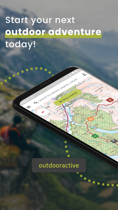
Outdooractive – Hike and Ride is a professional-grade outdoor navigation platform designed to help adventurers confidently explore nature with precision, safety, and inspiration. Whether you're hiking, cycling, skiing, or trail running, the app offers a vast library of officially approved routes, powerful planning tools, and the most reliable topographic maps available. Trusted by mountain guides, trail wardens, and outdoor professionals worldwide, Outdooractive empowers users to plan, navigate, and share their outdoor experiences with unmatched accuracy and ease.
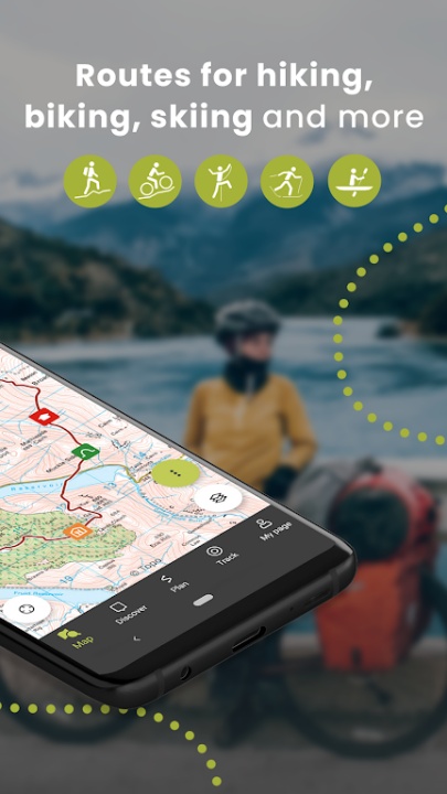
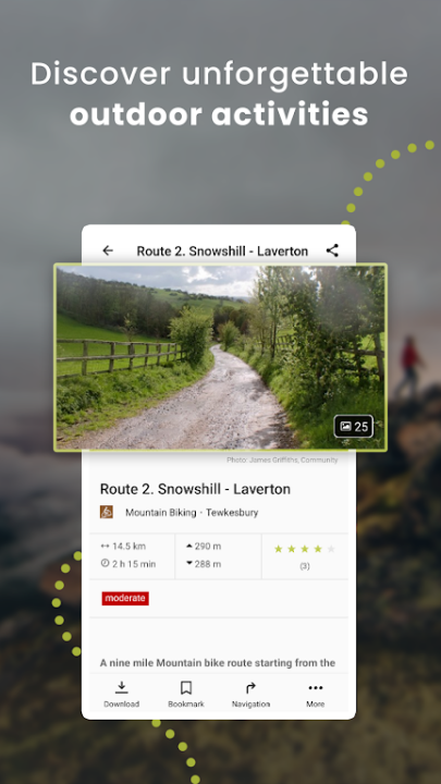
Discover Verified Routes Worldwide
- Explore thousands of curated and officially approved routes tailored to your favorite outdoor activities.
- Access hiking, trekking, mountain biking, ski touring, gravel riding, horseback riding, mountaineering, and trail running routes.
- Browse routes by location, difficulty, elevation, and terrain type.
- View expert insights, safety notes, and route highlights before heading out.
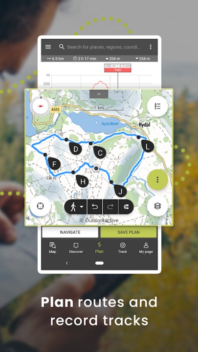
Plan Custom Adventures with Professional Tools
- Take control of your outdoor experience by designing your own routes with detailed planning features.
- Use the intuitive route planner to plot paths with elevation profiles, distance, and terrain data.
- Customize routes based on your fitness level, time constraints, and preferred activity.
- Save and edit routes for future use or share them with the Outdooractive community.
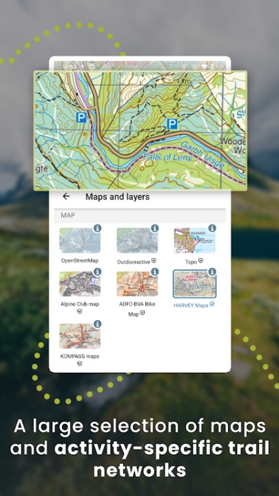
Navigate with the World’s Most Reliable Maps
- Outdooractive offers the most comprehensive collection of topographic and official maps from around the globe.
- Access official topo maps from 25+ countries, including Ordnance Survey (UK), USGS (USA), IGN (France), Swisstopo (Switzerland), and more.
- Switch between map layers to view terrain, trails, elevation, and land use.
- Use Alpine Club maps and Outdooractive’s custom maps for high-altitude and alpine navigation.
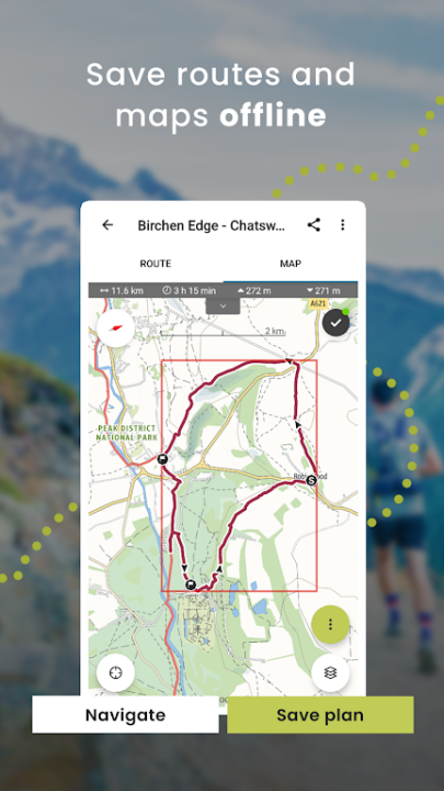
Offline Access for Remote Exploration
- Stay on track even when you're off the grid with robust offline capabilities.
- Download individual routes or entire regions for offline use.
- Navigate confidently in areas without mobile signal or data coverage.
- Save battery by using offline maps in flight mode during long treks.
Real-Time Location Sharing with BuddyBeacon
- Enhance safety and peace of mind by sharing your live location with trusted contacts.
- Activate BuddyBeacon to allow friends and family to track your position in real time.
- Ideal for solo hikers, remote expeditions, or group coordination.
- Customize visibility settings for privacy and control.
Join a Global Outdoor Community
- Connect with fellow explorers and stay motivated through shared experiences and challenges.
- Share your recorded tracks, photos, and reviews with the Outdooractive community.
- Participate in seasonal challenges and discover new destinations through community content.
- Follow official partners and tourism boards for curated route suggestions.
Smartwatch Integration and Wearable Support
- Stay informed and hands-free with smartwatch compatibility.
- Use Wear OS smartwatches to view GPS position, record tracks, and navigate routes.
- Monitor progress and receive turn-by-turn guidance directly on your wrist.
- Sync with your mobile device for seamless data transfer and route updates.
Additional Features
- Calendar and Activity Log: Track your outdoor history and revisit past adventures.
- Augmented Reality Tools: Use Skyline to identify peaks and landmarks in real time.
- Fitness Sync: Connect with Garmin, Strava, Suunto, and other fitness platforms.
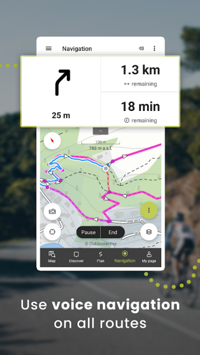
- Speech Navigation: Get voice-guided directions for hands-free exploration.
- Map Customization: Adjust map themes, overlays, and visibility settings to suit your needs.
Frequently Asked Questions
Q: Can I use Outdooractive to find trails near my current location?
Yes, the app helps you discover nearby hiking, biking, and outdoor routes based on your GPS location.
Q: Are the maps available offline?
Yes, you can download maps and routes for offline use in areas without signal.
Q: How accurate are the maps and route data?
Outdooractive uses official topographic maps and verified route data from trusted sources and partners.
Q: Can I plan my own routes?
Yes, the app includes a powerful route planner with terrain, elevation, and distance tools.
Q: Is there a way to share my location with others while hiking?
Yes, BuddyBeacon allows you to share your live location with friends and family for safety.
Q: Does the app support smartwatches?
Yes, Outdooractive supports Wear OS smartwatches for GPS tracking and navigation.
Version History
v3.17.1 —— 12 Jul 2024
Bug fixes & performance improvements—general refinements to enhance app stability and responsiveness.
v3.16.7 —— 13 May 2024
Track recording enhancements—simplified activity switching for hiking, cycling, and running.
Customizable display—choose which statistics to view during track recording.
Smart naming suggestions—automatically generate track names for easier sharing.
v3.16.6 —— 5 May 2024
Same updates as v3.16.7—continued rollout of improved tracking and personalization features.