OsmAnd is a feature-rich, privacy-focused offline navigation and mapping platform powered by OpenStreetMap. Tailored for explorers, commuters, and professionals alike, the app offers highly customizable routing, offline map layers, terrain visualizations, and advanced track recording. With built-in support for editing OSM data and robust tools for outdoor and off-road navigation, OsmAnd provides precision and flexibility without requiring an internet connection or compromising your privacy.
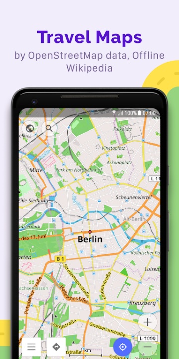
Detailed Offline Map Viewing
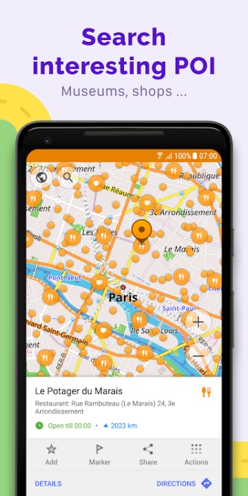
- Comprehensive and customizable cartography.
- Display points of interest such as attractions, food, healthcare, and transportation hubs.
- Search by address, place name, coordinates, or categorized tags.
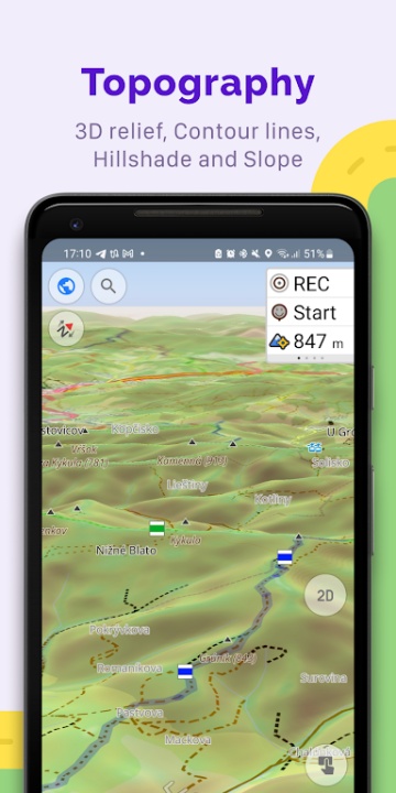
- Choose from specialized map layers: topographic, desert, nautical, winter/ski, and off-road.
- Apply terrain shading, contour lines, and data overlays for enhanced visual interpretation.
- Stack multiple map sources together to achieve a hybrid view tailored to your activity.
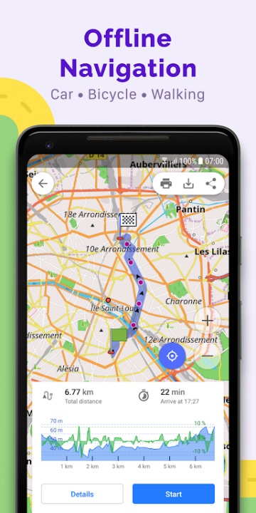
Fully Customizable GPS Navigation
- Precision routing for all transport modes.
- Create offline routes with advanced control over roads, terrain, and accessibility.
- Select profiles for cars, trucks, bikes, motorcycles, 4x4s, pedestrians, boats, or transit routes.
- Avoid specific road types or surfaces with dynamic route recalculation options.
- Display route stats with real-time widgets showing distance, ETA, speed, and turn-by-turn prompts.
- Navigate intuitively on trails, water routes, or restricted paths that often go unmapped in commercial GPS apps.
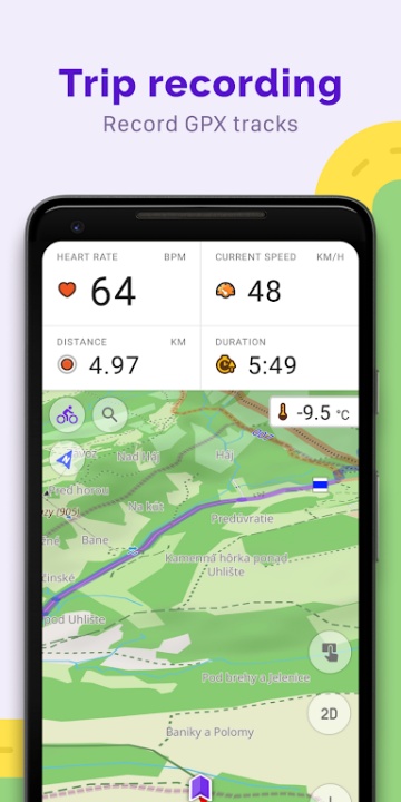
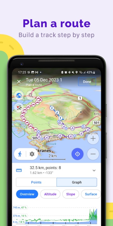
Advanced Route Planning and GPX Recording
- Perfect for outdoor adventurers and road travelers.
- Manually define multi-point routes or automatically generate tracks by travel type.
- Record your own movement as a GPX file with real-time elevation, speed, and timestamp logging.
- Import, manage, and follow previously saved or downloaded GPX tracks directly on your map.
- Visualize altitude profiles, ascents and descents, and segment distances with offline precision.
- Option to upload and share GPX tracks with the OpenStreetMap ecosystem.
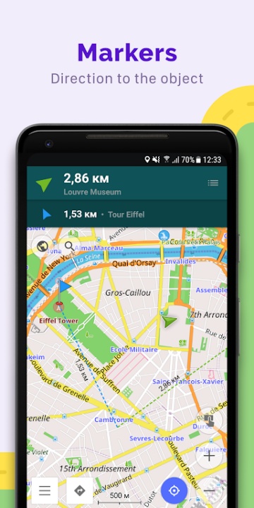
Point-Based Notation and Landmark Creation
- Pin, label, and document your journey.
- Add Favorites for frequently visited or notable spots.
- Mark any point with customizable labels and icons for quick recognition.
- Attach audio or video notes to specific locations to enhance travel journaling or field documentation.
- Great for field research, nature observation, or personal route reference.
Live and Editable OpenStreetMap Integration
- Stay connected to community-driven data.
- Make real-time or offline contributions to OSM, including naming, navigation fixes, and place edits.
- Update your maps as often as every hour to stay aligned with global community updates.
- Be part of a growing user base helping refine global cartographic accuracy.
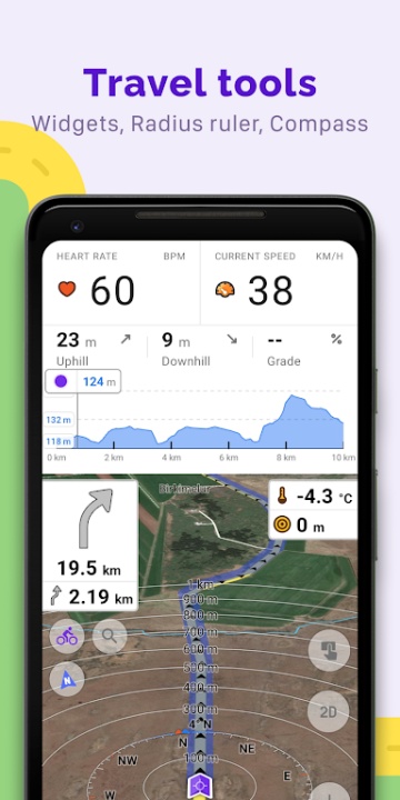
Additional Utilities for Explorers and Cyclists
- Augment your travels with smart tools.
- Use the compass and radius ruler for orientation, distance estimation, or geographical planning.
- View Mapillary imagery to access street-level views within the app.
- Switch to night mode for low-light navigation.
- Access Wikipedia integration for offline knowledge about landmarks and destinations.
Premium Features with Maps+ or OsmAnd Pro
- Go even further with enhanced tools.
Maps+ (in-app purchase or subscription):
- Access Android Auto support for in-car navigation.
- Download unlimited maps, contour lines, and terrain elevation data.
- Use offline Wikipedia and Wikivoyage travel guides and nautical depth charts.
OsmAnd Pro (subscription):
- Enable cross-platform cloud backup and sync via OsmAnd Cloud.
- Enjoy hourly map updates and external sensor integration via ANT+ and Bluetooth.
- Use weather plugins, elevation widgets, and route line customization tools.
- Access detailed online elevation profiles and meteorological overlays.
Frequently Asked Questions
Q: Can OsmAnd be used completely offline?
Yes, all core features including routing, map browsing, and GPX recording work without internet access.
Q: Is my location or map data shared with anyone?
No, OsmAnd does not collect or transmit user data, preserving full privacy.
Q: What is the difference between Maps+ and OsmAnd Pro?
Maps+ adds advanced offline features, while OsmAnd Pro includes cross-platform syncing and external hardware support.
Q: Can I use OsmAnd for boating or marine navigation?
Yes, nautical maps and depth charts are available through paid upgrades.
Q: How often are map updates available?
Hourly updates are available with OsmAnd Pro, while standard users receive regular public releases.
Q: Are GPX tracks shareable?
Yes, you can export and optionally upload them to OpenStreetMap.
Q: Does the app support Android Auto?
Yes, Android Auto integration is included in the Maps+ plan.
Version History
v5.1.2 —— 19 Jun 2025
Web & cross-platform purchases—added support for broader payment flexibility.
Temperature unit settings—moved to General settings for easier access.
BLE sensor battery indicator—monitor battery levels directly in-app.
Navigation UI update—more intuitive point selection interface.
Widget visibility—improved with new outline styling.
Uphills/Downhills analyzer—visualize elevation changes along your route.
Wikipedia & Wikivoyage integration—expanded POI coverage.
v5.0.5 —— 29 Apr 2025
Explore mode—discover top-ranked POIs with a new interface.
Searchable OSM routes—find hiking, cycling, MTB, and more.
Navigation widget—combined turn arrow and instructions.
Route info widget—displays ETA, arrival time, and distance.
Ski & MTB trail selection—tap for detailed information.
Widget sizing—choose dimensions for left/right panels.
Coordinates grid—added geographical grid overlay.
v4.9.10 —— 14 Dec 2024
Wikimedia gallery viewer—full-screen image browsing.
Vehicle Metrics plugin—monitor performance via OBD-II.
Track activity tagging—assign and filter by activity type.
Quick actions—new shortcuts for trip recording and screen lock.
Map button customization—adjust appearance and layout.
Widget enhancements—context menu and average speed reset.
Dirt Bike trails—new route layer added.