FLY is FUN Aviation Navigation
Your Ultimate Aviation Companion
• Designed by pilots for pilots, FLY is FUN transforms your tablet into a comprehensive, high-performance flight deck.
• Whether you are planning your next cross-country or navigating complex airspace, our app provides the situational awareness and precision you need to fly with confidence.
• Experience the freedom of professional-grade navigation, now accessible to everyone.
Key Features for Seamless Navigation
1. Dynamic Flight Planning:
• Effortlessly build and edit routes via intuitive drag-and-drop.
• Calculate fuel, time, and distance based on real-world wind and aircraft performance.
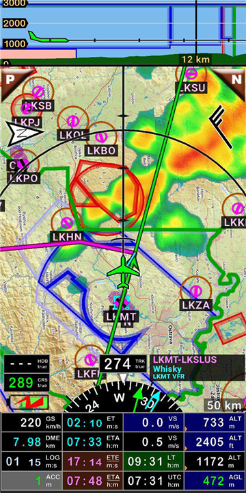
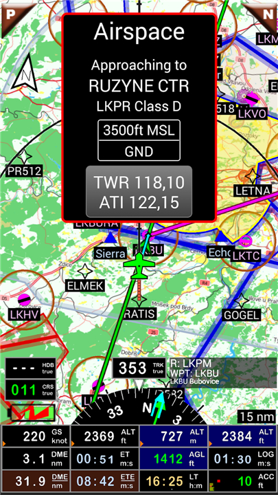
2. Smart Situational Awareness:
• Receive proactive alerts for controlled airspace, reporting points, and terrain.
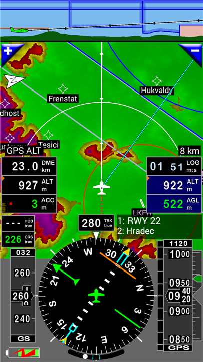
• Visualize your path with a moving map that offers IFR/VFR customization.
3. Virtual Avionics:
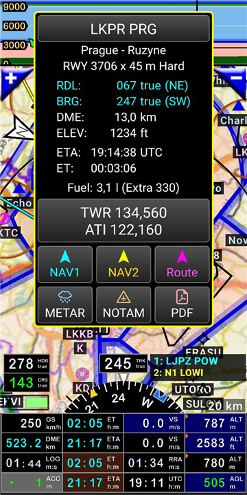
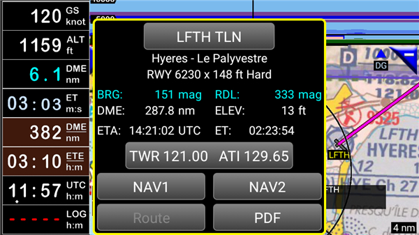
• Simulate ILS, VOR, NDB, DME, and RNAV approaches—even without dedicated on-board hardware.
4. Integrated Data:
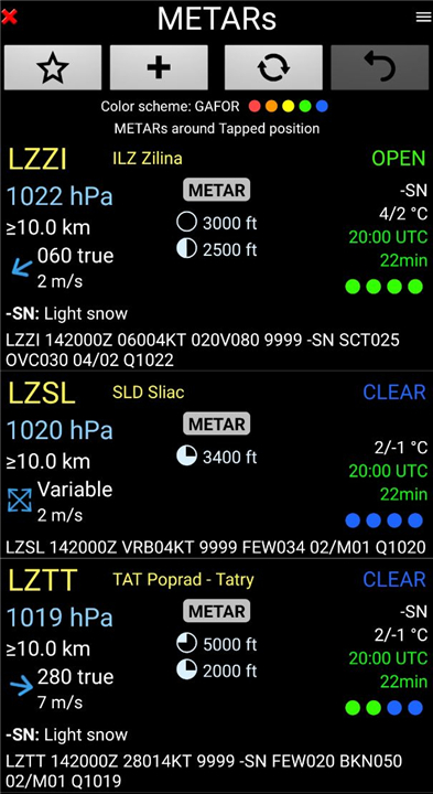
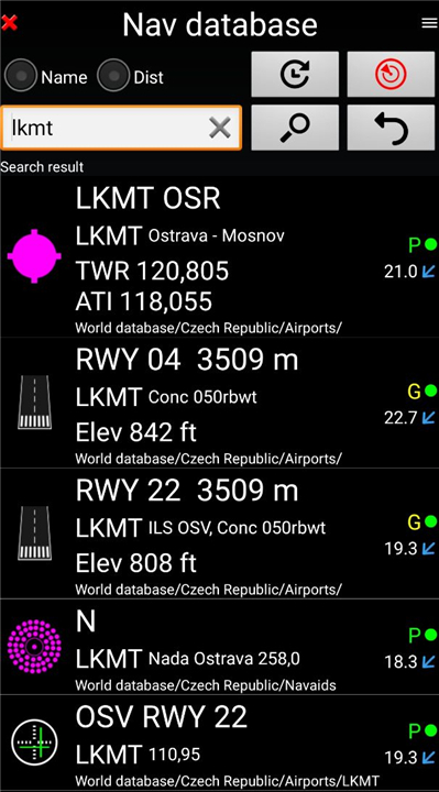
• Access real-time weather, rainfall radar, NOTAMs, and AIRAC-updated navigational databases.
5. Advanced Compatibility:
• Fully supports STRATUX receivers and external Bluetooth GPS devices.
Total Customization
• Tailor your cockpit to your specific mission.
• With 10 custom screen layouts and over 100 data fields—such as ground speed, vertical speed, and DME—you control exactly what information is in your line of sight.
• Our map scales intelligently, providing more detail the closer you zoom.
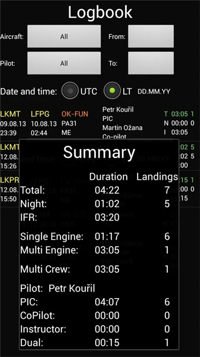
Logbook and Documentation
• Automatically track every flight with our integrated logbook.
• Record departure/arrival times, flight tracks, and pilot details, then export your flight history to Google Earth for detailed post-flight analysis.
• Plus, easily store and access your own PDF documents, AIPs, and VACs for over 50 countries.
Charts and Global Coverage
• Choose your preference from a vast library of charts.
• We support open-source options alongside premium commercial providers like ICAO, Cartabossy, SkyVector, and FAA sectional charts.
Get Started
• Experience the difference during your free trial period.
• Following the trial, a simple annual subscription ensures you continue to receive the latest updates while directly supporting our ongoing development.
Important Note:
• FLY is FUN is designed for VFR flight only.
• Pilots are responsible for safe navigation and compliance with all aviation regulations.
Support and Resources
• User Guide: Download Manual
• Feedback and Support: www.flyisfun.com
FAQ
Q: How can I customize the flight deck to show only the information I need?
A: You have complete control over your cockpit view through the customization settings. You can select from ten different screen layouts and choose from over one hundred data fields to ensure that essential information like your ground speed or vertical speed is always in your line of sight.
Q: Does the app support external GPS hardware?
A: Yes, FLY is FUN is designed to be highly compatible with your existing equipment. It fully supports both STRATUX receivers and a wide range of external Bluetooth GPS devices to ensure you have precise location data during your flight.
Q: How do I build a flight route within the app?
A: Building a route is simple and intuitive. You can use the drag-and-drop feature on the map interface to create or edit your flight path effortlessly. The app will then automatically calculate your fuel, time, and distance requirements based on current aircraft performance and real-world wind data.
Version History
v36.33——22 Jun 2026
FLY is FUN - navigation for pilots 30 days trial version Download the latest version of FLY is FUN Aviation Navigation to enjoy new features and updates immediately!
*36.55
- Default settings refactored (at Display settings window)
- New airspace icons at the lists - they look exactly like on map. If you change color of the airspace, the icon will be changed too.
- Removed crash after adding pilot to list.
*36.52
Refactored Download topo maps
*36.51
- Refactored Screen customize and it was renamed to Display settings (Long press the compass rose).
- Improved map downloads – much more stable even with a poor internet connection